
So you’re thinking about paddling the Mississippi River? Great! Below is my guide, based off my experience canoeing the river in 2017. The opinions here are my own and I have tried to provide the most accurate data to the best of my knowledge.
Throughout the guide you will see links to Amazon for various gear items. I am part of Amazon’s affiliate link program and may receive a small commission if you buy a piece of gear through a link. I have extensively field tested all the gear I have linked in the guide and would recommend each item 100%. Items that I have used and would not recommend are not linked. This guide is not sponsored by any of the companies the gear is from. I participate in this program to generate a small amount of money to cover the operating expenses of the website.
Please e-mail me at zanaridg@gmail.com if you have any questions about the content or about paddling the river, or if there is something that is not accurate here. If you find this content helpful, please consider a small donation towards the site.
Thanks!
[wp_paypal button=”donate” name=”ITWO Donation”]
Google Drive (Minnesota DNR Maps, US Army Corp Maps, MSR Spreadsheet)
Where does it start and end? The Mississippi River starts in Lake Itasca in Minnesota and meanders roughly 2,320 miles south where it eventually deposits into the Gulf of Mexico in Louisiana. The river passes through 10 states (Minnesota, Wisconsin, Iowa, Illinois, Missouri, Arkansas, Kentucky, Tennessee, Mississippi, and Louisiana), forming a natural border between them. There are 4 distinct sections of the river: 1: The Upper Mississippi River (UMR) from the headwaters to the first lock and dam in Minneapolis. This is a 486 mile stretch through mostly wilderness with the cleanest and clearest water of the entire river. The river is narrow and punctuated by several large lakes throughout. It also has many portages. 2: The UMR between the first lock and the last lock just north of St. Louis. This is a 665 mile stretch through the lock and dam system, comprising 27 locks. 3: St. Louis to the Atchafalaya River cutoff, through the Lower Mississippi River. This is a 649 mile stretch. The river is fast and free flowing. The river is very wide and has a lot of large barge traffic. 4: The remaining miles to the Gulf, either through the Atchafalaya River (160 miles) or the Mississippi River through Baton Rouge and New Orleans (304 miles). We took the Atchafalaya and highly recommend this route. 
When is the best time to go? The season generally starts when it is warm enough to paddle in Minnesota (i.e. snow and ice are melted), which is usually between April and May. It ends when the weather becomes too cold to paddle the first quarter of the river safely (typically late September to early October, depending on the year). I wouldn’t start too much later than Labor Day weekend. We started August 25th and this was a good time for us. Flow is stronger and faster in Minnesota early in the season and generally slows down as the season progresses. In late August, there were many areas within the first several hundred miles where the water was low enough to where we had to walk the canoes for a short distance. This doesn’t seem to be an issue when the water level is higher earlier in the year. For my trip, on average, the river flowed 1 mph or less above the last lock and dam near St. Louis. After that, the flow averaged around 3-4 mph. Keep in mind it does get very hot in the south during the summer. The mosquitoes that time of year are also relentless. A late summer/ early fall start will have you moving with the autumn season, ending in the south in October and November, which have typically cooler and more pleasant temperatures. I was happy starting in late August, even though the flow of the river was slower. 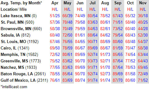
How long does it take? It depends a lot on the conditions and how the water is moving. Two to three months would be a typical range. It took us 75 days with fairly slow water. Your daily averages will vary. 30 mile days were normal for us on the Upper River (when flow was 1 mph or less), and 50 mile days were normal for us on the Lower River (when flow was 3-5 mph). Wind impacts daily averages the most. Sometimes you are forced off the river if winds exceed 15 mph as a headwind or crosswind. Below is a day by day breakdown of our progress. Days with 0 miles: 6 Days less than 10 miles: 2 Days 10 to 19 miles: 7 Days 20 to 29 miles: 21 Days 30 to 39 miles: 25 Days 40 to 49 miles: 9 Days 50 to 59 miles: 5 Longest mile day: 59 
Day
End Location
Distance
Total
1
Wanagan Camp-DNR (U1337)
6
6
2
LaSalle Bluffs Camp-DNR (U1324.5)
13
19
3
Iron Bridge Camp-DNR (U1301)
24
43
4
Stump Lake Camp-DNR (U1279)
22
65
5
Meadows Camp-DNR (U1251)
28
93
6
Winni Dam Recreation Area (U1229)
22
115
7
Schoolcraft State Park (U1199)
30
145
8
Grand Rapids Hotel, Grand Rapids, MN (U1179)
20
165
9
Blackberry Camp-DNR (U1163.5)
15
180
10
Weeping Willow Camp-DNR (U1128)
36
216
11
Scott’s Rapids Camp-DNR (U1102.5)
25
241
12
Hassman Camp -DNR (U1068)
35
276
13
Lone Pine Camp-DNR (U1036)
33
309
14
Brainerd, MN/ Warm Shower’s (U1003)
32
341
15
Zero in Brainerd, MN
0
341
16
Fletcher Camp-DNR (U971)
30
371
17
Seven Isalnds Camp-DNR (U941)
23
394
18
Boy Scout Point Camp-DNR (U918)
34
428
19
Ostego, MN/River Angel (U884)
32
460
20
North Mississippi River Regional Park (U852)
27
487
21
Stealth Camp 01 (U825)
28
515
22
Stealth Camp 02 (U797)
31
546
23
Redwing, MN, Harbor Bar (U766)
10
556
24
Alma, WI, Brian’s (U756)
40
596
25
Riverside Park (U716)
35
631
26
Municipal Boat Landing, LaCrosse, WI (U697)
20
651
27
Zero Day, LaCrosse, WI
0
651
28
Stealth Camp 03 (U664)
33
684
29
Stealth Camp 04 (U636)
28
712
30
Stealth Camp 05 (U606)
30
742
31
Stealth Camp 06 (U584)
32
774
32
Stealth Camp 07 (U541)
33
807
33
Albany, IL/River Angel’s (U514)
27
834
34
Stealth Camp 08 (U483)
31
865
35
Ducky’s Lagoon, Andalusia, IL (U472)
11
876
36
Zero Day, Andalusia IL/ Friend’s House
0
876
37
Zero Day, Andalusia IL/ Friend’s House
0
876
38
Zero Day, Andalusia IL/ Friend’s House
0
876
39
Stealth Camp 9 (U450)
22
898
40
Stealth Camp 10 (U427)
23
921
41
Stealth Camp 11 (U399)
28
949
42
Camp Eastman (U369)
30
979
43
Stealth Camp 12 (U340)
29
1008
44
Stealth Camp 13 (U328)
13
1021
45
Hannibal, MO, Marina/ Best Western (U309)
19
1040
46
Stealth Camp 14 (U280)
29
1069
47
Stealth Camp 15 (U244)
36
1105
48
Stealth Camp 16 (U205)
39
1144
49
Chain of Rocks/ River Angel’s (U191)
15
1159
50
Stealth Camp 17 (U145)
45
1204
51
Stealth Camp 18 (U102)
43
1247
52
Stealth Camp 19 (U54)
48
1295
53
Stealth Camp 20 (U18)
36
1331
54
Stealth Camp 21 (L912)
59
1390
55
New Madrid, MO, Boat Landing (L888)
24
1414
56
Stealth Camp 22 (L835)
53
1467
57
Stealth Camp 23 (L778)
57
1524
58
Mud Island Boat Ramp, Memphis, TN/ River Angel’s (L738)
40
1564
59
Zero in Memphis, TN
0
1564
60
Stealth Camp 24 (L701)
37
1601
61
Stealth Camp 25 (L661)
39
1640
62
Stealth Camp 26 (L618)
44
1684
63
Stealth Camp 27 (L575)
43
1727
64
Stealth Camp 28 (L547)
28
1755
65
Stealth Camp 29 (L495)
52
1807
66
Stealth Camp 30 (L442)
53
1860
67
Ameristar Casino Hotel, Vicksburg, MS (L436)
6
1866
68
Stealth Camp 31 (L393)
43
1909
69
Days Inn, Natchez, MS (L364)
29
1938
70
Stealth Camp 32 (L329)
35
1973
71
Stealth Camp 33 (A4)
36
2009
72
Melville, LA, Danny Majors (A30)
26
2035
73
Stealth Camp 34 (A62)
34
2069
74
Stealth Camp 35 (A104)
42
2111
75
Burns Point Park/ Gulf of Mexico
30
2141
What vessel should I take? People have had much success with either kayaks or canoes. Several people have even used stand up paddle boards. I would choose something that is comfortable and familiar to you, and something that you might already have access to. I cannot comment in any detail on specific kayaks, but it seems that people favor longer kayaks over shorter ones for stability in big water. As for canoes, we used a 15 foot Outchita and a 17 foot Grumman, both aluminum. Both were great boats, but the Grumman was better, especially in choppy water, since it sat higher on the water and handled waves much better. The Outchita had a lower profile and was more prone to taking on water in big waves. There were two occasions where the boat almost became swamped from taking on too much water. There are lighter composite canoes available as well, but I do not have any experience with these types. They are often more expensive, and are often not as durable as aluminum. Going through rocky sections in Minnesota in the aluminum was nice because we weren’t too afraid of hitting rocks with them. My only piece of advice is to try and get a longer boat, something over 14 feet. The water on the river is no joke, and something with a lot of stability in choppy water is very beneficial. Search on Craigslist in your area for canoes and kayaks. You are likely to find a good deal this way. 
How do I get myself and my boat to lake Itasca? There is no easy way to get to the start. It’s in a fairly remote location in Minnesota. Hopefully someone is able to drive you out there with your boat, which is what we did. You can either start at the municipal boat launch on the actual lake and paddle to the outflow (maybe a mile or so), or you can start at the actual headwaters itself. We chose to start at the actual headwaters, which includes a short gear carry (200 yards or so) to the headwaters from the Mary Gibbs Headwaters Center. 

How do I navigate the river? MAPS There are three map sets you will need for navigation (four if you plan to take the Atchafalaya to the Gulf). Click here to go to the Google Drive to download and view maps. 1: Michigan DNR Maps (Michigan DNR Website) The Minnesota DNR has a 9 map set of the river from Lake Itasca through to a few miles beyond St. Paul. This map set is very nice. It shows where DNR campsites are as well as portages, main towns, boat ramps, state parks, location of rapids, etc. It starts at mile 1341 (headwaters/ Lake Itasca) and counts down to mile 815, south of St. Paul near Lock and Dam #2. 2: US Army Corp Upper Mississippi River The US Army Corp of engineers has a map set of the Upper River, which comprises a few miles north of Minneapolis (mile 865) to the confluence of the Ohio river near Cairo, IL (mile 0). 3: US Army Corp Lower Mississippi River They also have a separate navigation map of the Lower River, from the confluence of the Ohio River (mile 953) through to the Gulf (mile 0). Note that the Upper and Lower River are on a different numbering scheme. 4: US Army Corp Atchafalaya (PDF Download | Website) The Army Corp also has a navigation map of the Atchafalaya River if you choose to exit to the Gulf via that route. The Atchafalaya is roughly 160 miles long and counts up, starting at 0 where the Atchafalaya branches away from the Mississippi River at Lower River mile 304. GPS Click here to go to the GPS page (comming soon). I used two types of digital maps, offline maps by OsmAnd, and Google Maps (when I had internet service) in satellite layer. Both came in handy. Satellite images were particularly useful when identifying where the river went, especially when there were a lot of islands or sloughs. A trick to use Google Maps when out of service is to load a section on your phone when you have service and keep that open on your phone. It will continue to work offline. I have developed a set of GPS tracks and way-points for use in OsmAnd to aide you on your trip. OsmAnd is available to download for free on both iOS and Android. I really like OsmAnd and have used it extensively during my travels. NAVIGATION TIPS Later in the season, the river is very narrow near the headwaters and often overgrown with wild rice. At times, you may have to push yourself through tall reeds without knowing exactly where you are going. If you have doubts, try and follow the direction of the current at junctions. It is often hard to take a wrong turn, so even if you have gone down an unfavorable path, chances are it will link back with the main river. Check google maps to see where you are if you get confused. There are many large lakes in Northern Minnesota that you paddle through, such as Cass Lake and Lake Winnibegoshish, which is 8 miles wide. Respect these lakes. Winds over 5-7 miles an hour will be a problem on these big water bodies. Don’t cross through the middle of the lake if the wind is bad, and check a forecast before committing to going across the center. Lake Winnibegoshish took us almost 4 hours to cross in bad wind, which got worse as we approached the center. Once you are out there you cannot bail out. Follow the south shore around the lake if the wind is unfavorable (or if there are storms in the area). I wish we did this. After you portage through downtown Minneapolis, the navigation channel will be present with red and green buoys. Going downstream, stay right of red buoys, and left of green ones. Red and green have different shapes on top, too, in case you can’t make out the color. Red have coned tops and green have flat tops. Knowing that you are in our out of the main channel is important when navigating past barges and other recreational traffic. The navigation channel tends to stay to the outside bend of the river. It is safer to stay on the inside bend as barges favor the outside bend. Stay in the navigation channel as much as you can, the flow is faster and it is safer there. This is especially true on the Lower River to avoid dangerous wing dam currents. Wing dams are a line of rocks that direct the flow of the river. They are below the water level on the Upper River and above water level on the Lower River. On the upper river you have more freedom where you can go, and sometimes it makes more sense to take a slough or go a different way around an island instead of staying in the main channel. Give yourself enough time to cross the channel if you have to cross. Check where the barges are. They are slow, but move more quickly than you think. They cannot stop easily, so it is advised to give them plenty of space. They also will not see you the majority of the time, so never think that they are moving in a manner that benefits your position. The wake from barges are not a problem until the Lower River, where the current seems to manipulate the wake and energizes the waves. Two barges that pass you going upstream back to back will create a lot of chop. Be careful in these situations. Never position yourself directly behind a tugboat, or attempt to cross the channel immediately after the barge has passed you. They generate big standing waves that take some time to dissipate. Recreational boaters are the biggest threat on the river. These are people in fishing boats, pontoons, jet skis, luxury cruisers, etc. The wake from luxury cruisers are the worst. Position yourself so you face into oncoming waves until they pass you. 


Where do I camp? Camping is easy in Minnesota on the Upper River. There are many designated DNR sites. Most of these sites include a pit toilet and some even have a lean-to. Plan your days to end at one of these sites up until Minneapolis. Beyond Minneapolis, the camping becomes a little difficult. Make sure to start looking for a place to camp an hour or an hour and a half before sunset. Your first pull off point may not work and you may have to continue paddling to find something else. With some effort you will always find something that will work. In the GPS guide (comming soon) I list all the locations where we camped as a reference. Some people enjoy camping on the sandbars (which there are plenty of, especially south of St. Louis), which is an option, but we tried to avoid camping in such an exposed location. Sand bars are pretty, yes, but sandy (sand is annoying when it gets into all your gear) and subject to wind. Since you are near a body of water, you will likely wake up with a wet tent almost every morning due to condensation. Finding something in the trees will keep your tent dry, as the canopy will block the moisture, protect you from wind, and provide more shelter during rain events. The vegetation offshore can be thick at times within the woods. We found that walking into the woods several hundred yards would often lead to spots where vegetation was absent. Be responsible with fires. I don’t build fires anymore on any of my trips (they take too much time and effort, and are the last thing I want to worry about at the end of a long day), but I understand that many people enjoy them. Make sure the fire is out completely before leaving camp by dousing it with water. Use a fire ring if one is provided. Tents and hammocks both work well on the river. I wouldn’t give the advantage to either one of them, so use whichever one makes you sleep better. 
Where do I resupply for supplies along the way? There are many towns you will pass through along the way. We resupplied every 4-6 days on average, mostly at Super Walmart’s, but also at small and medium sized grocery stores, and a few dollar stores. Food opportunities are plentiful on the river, especially the Upper River. The longest stretch is between Memphis and Vicksburg, almost 300 miles, which we did in 8 days. Please refer to the GPS Guide (comming soon) for more information on where the actual grocery stores are located in each of the following towns. The guide also lists most of the restaurants we ate at! The following towns and cities are where we resupplied. U=upper river mile marker, L=lower river mile marker, A=atchafalaya mile marker Towns in red symbolize stops where we received rides into town, so stores may not be within walking distance. An alternative to Ostego, MN is Monticello, MN (U897); an alternative to Andalusia is Davenport, IA or Rock City, IL (U483); an alternative to St. Louis is Alton, IL (U202) 

What about water? Grab yourself a 5-7 gallon water jug. We used the Reliance Aqua-Tainer 7 Gallon Rigid Water Container which had a spout (very useful). 7 gallons was good for around 4-5 days for two adult men before having to refill (although this really depends on hot it is). You will need to be resourceful finding where to re-fill water. We refilled anywhere from parks, hotels, restaurants, and private residences.
What are portages like? Portages are fairly annoying on the upper river before Minneapolis. There are 13 portages. Many of these are easily accomplished, but there are a few long portages, including Blanchard Dam, a half mile portage through a hiking trail, and the portage through downtown Minneapolis, which is a mile and a half along a bike path. The portage through Minneapolis bypasses Upper and Lower St. Anthony Falls Lock and Dams, due to their closure in 2015 to prevent the invasive Asian Carp from migrating further up river. We carried one dolly to use for both our canoes, and this was helpful for the long portages. Portages take time but they aren’t too terrible. I would consider taking less things prior to entering the Lock system since it will make the portages a bit easier to manage. If traveling alone, be careful about leaving gear unattended while portaging (or when going into town). We had heard stories of individuals getting boats and gear stolen. Consider bringing along a cable lock that you can use to lock your boat to a tree or sign. We used this often when leaving boats behind to go into town. Blandin Dam: Minnesota Energy Company will portage you for free if you give them a call (number is on a sign when you take out from Pokegama Dam, a few miles north of Blandin) 

What is the lock system like? There are 29 Locks and Dams on the Upper River but you will only pass through 26 of them (Upper and Lower St. Anthony are closed, and the last lock, Number 27, you will bypass through the Chain of Rocks Portage near St. Louis). The first few locks are neat but the novelty wears off by the third lock. They are fairly annoying and time consuming, especially if you have to wait for a barge to lock through before you are allowed to go. A list of the Lock and Dam phone numbers and mileages are below and also located in the MSR Spreadsheet. My recommendation is to call the Lock Master when you are between a mile and a half mile away, and tell them you are nearing the lock and would like to lock through. They will tell you whether it will be safe to approach, or whether you will need to wait for a barge. If there is a barge, they will often tell you how long it will be before you can go. Ask them where a safe place is to wait for the lock if the barge is coming upstream. If you catch the lock at a bad time (i.e. a barge has just begun to lock through), you will be waiting up to 2 hours for your turn. This stinks but there is no way around it. We lost a lot of paddling time waiting around for barges to lock through. Barges take such a long time because they have to be broken apart and locked through in stages if they can’t fit in one go. If you can’t get a hold of the lock master by phone, there are pull cords as you approach the lock to signal a lock-through. Pull on the cord. Sometimes the Lock Master will communicate via an outside speaker, but this is not always the case. There is a light near the opening of the lock. Red means don’t approach. Yellow means approach with caution. And green means enter the lock. Once the light turns green, enter the lock. There will often be a person to greet you in the lock, and they will tell you how far to pull in. They will hand you a rope to hold onto as the water is lowered. Near the last three locks, we were not offered a rope, and just waded in the center of the lock as the water was lowered. Never tie off to a ladder or other stationary object in the lock. It won’t end well for you. Ask questions to the guys and gals working the lock if you are confused, they are very helpful. Once the doors open on the other side, wait for the horn to proceed out of the lock. It will be a short but very loud blast. Be careful leaving the lock, especially if it is windy. Waves will bounce all over the place and sometimes it will be very difficult to paddle out. Use caution. Once you lock through the first couple of times you’ll start feeling pretty comfortable doing it. The Army Corp will never lock you through with a barge, but you may be sharing the lock with other pleasure craft at times. The Lock Masters and crew were overall very accommodating and helpful, with the exception of one very rude employee at Lock and Dam 26, but maybe he was having a bad day. This lock receives a lot of barge traffic due to its proximity to the port of St. Louis. If you can afford a Marine Radio it may be worth bringing it along. You can communicate with the Locks this way too, and can use it to communicate with barges. It would also be handy to radio for help if an emergency situation arises. With that being said, we were fine without one. 
Lock
Mile (Upper River)
Bank
City
Phone#
Upper St. Anthony
854
Left
Minneapolis, MN
612-333-5336
Lower St. Anthony
853
Right
Minneapolis, MN
612-332-3660
1
848
Right
Minneapolis, MN
612-724-2971
2
815
Right
Hastings, MN
651-437-3150
3
796
Right
Welch, MN
651-338-5794
4
753
Left
Alma, WI
608-685-4421
5
738
Right
Minnesota City, MN
507-689-2101
5a
729
Right
Fountain City, WI
507-452-2789
6
714
Left
Trempealeau, WI
608-534-6424
7
703
Right
LaCrescent, WI
507-895-2170
8
679
Left
Genoa, WI
608-689-2625
9
648
Left
Eastman, WI
608-874-4311
10
615
Right
Guttenberg, IA
563-252-1261
11
583
Right
Dubuque, IA
563-582-1204
12
567
Right
Bellevue, IA
563-872-3314
13
523
Left
Fulton, IL
815-589-3313
14
493
Right
Pleasent Valley, IA
309-794-4357
15
483
Left
Rock Island, IL
309-794-5266
16
457
Left
Illinois City, IL
309-537-3191
17
437
Left
New Boston, IL
309-587-8125
18
411
Left
Gladstone, IL
309-873-2246
19
364
Right
Keokuk, IA
309-524-2631
20
343
Right
Canton, MO
573-288-3320
21
325
Left
Quincy, IL
217-222-0918
22
301
Right
New London, MO
573-221-0294
24
273
Right
Clarksville, MO
573-242-3524
25
241
Right
Winfield, MO
363-566-8120
Melivn Price
201
Left
Alton, IL
618-462-1713
27
185.5
Left
Granite City, IL
618-452-7107

What gear did you bring? There is a lot to talk about here. I come from an 8,000+ mile long distance hiking background, so I already had a firm grasp on the camping gear and clothing that has worked for me in the past. But the biggest hurdle was figuring out what additional items I needed for a river trip since I had never done anything of this nature before. The biggest thing I had to think about was how to keep my gear dry. For my main dry bag, I went with the SealLine Black Canyon Boundary Pack. I used the 70 liter version which has shoulder straps so that you can use it as a backpack while carrying it around. Using it as a backpack was really helpful when portaging and carrying things into town. I really liked this bag, and it worked like it should. The contents inside never got wet, and the sizing was right for the amount of gear I had. The closing mechanism cinches the bag really tight, and I think this is a big improvement over typical dry bags that only have roll tops. The one minor gripe I had with it was after using it for two weeks, it would not hold an airtight seal. I would close the bag, and about an hour later, it would be slightly deflated. This was never a problem because nothing got wet (even during a day of really heavy rain and waves), but it was slightly annoying knowing that it wasn’t perfectly airtight somewhere. Regardless, I really liked this bag and would definitely recommend it. In addition to the main dry bag, I carried a 5 Liter Sea to Summit Big River Dry Bag to use as a bag to hold things I wanted easy access to during the day, like my phone and camera and wallet. It was an okay bag. Moisture did get in the top a few times during the trip when the bag was completely soaked through, but it performed well other than that, and the contents inside always stayed dry. I was able to clip the bag to my seat to prevent my most valuable items from floating away if the boat ever flipped. My friends used plastic tote boxes as their water-proof container to keep things they wanted easy access to dry. It seemed to work well for them. For the canoes, we purchased folding seats to clip onto the seats in the canoe. These seats had a back and this was one of the best canoe-related items we purchased for the trip. We used the GCI Outdoor SitBacker Canoe Seat and they worked well for the entirety of the trip. I would invest in a decent paddle. Three of us used the Bending Branches BB Special Canoe Paddle. They were relatively light and felt good to grip. It was a good balance of price, weight and performance. There are super light carbon fiber paddles, but unless you are a serious paddler outside of this trip, it probably isn’t worth the investment, unless you can sell it after the trip. We brought a cooler but never used it to keep anything cold. I would skip the cooler and opt for a plastic tote box or separate dry bag to keep your food in. The other canoe had a cooler and they used it often to keep hummus and cheese cold, but I always thought it was more hassle than what it was worth. If you want to get a cooler, I would suggest getting something cheap, as it will likely get banged up during your trip, and if you feel you don’t really want it anymore it’s easier to just get rid of along the way. A large sponge and bucket. Bring these along. They will be helpful in keeping the boat clean of mud and excess water. The bucket can also be used to pee in if you can’t get to a bank easily to relieve yourself while on the river. Make sure you have things to protect you from the sun. You will be on the water all day, and the sun can be really intense. I have used the Sunday Afternoons Men’s Charter Hat for the past two years to protect my face and head. I love this hat and can’t recommend it enough. Long sleeve shirts, like this one from Columbia (Silver Ridge Lite Long Sleeve Shirt), have been my my go-to for awhile now. I’ve owned several of these shirts. They have built in UPF protection and are really light and airy. They also dry very fast if they get wet. Consider bringing along a Buff to protect your neck and face further. Buff’s are also good to keep warm during cold weather. I’m mixed on paddling gloves. I used the NRS Boater’s Gloves and they worked good even though I didn’t use them a lot. I preferred to hold the paddle with my bare hands since it felt better. Other’s in the group ended up buying cheap pairs of work gloves (like for gardening) at Walmart and had good success using these. Footwear. I had three pairs of shoes, a pair of Teva Hurricane XLT Sandals, which were great, a pair of Altra Lone Peak 3.0 I originally bought a pair of Dexshell Coolvent Mid-Calf Waterproof Socks, and have mixed feelings about them. They do work, but after they get wet on the outside they have a hard time drying. Something like these would work better for hiking in cold and wet weather rather than on a canoe trip. After getting the mud boots I never wore the socks again. They did work though, and they are waterproof. If you are in the market for some these were a good brand. For rain protection, the Frogg Toggs Packable Adult Poncho work pretty great. I also had a rain jacket (also good for wind protection) and a pair of cheap rain pants. My rain pants came in handy during cold mornings as well. My rain Jacket was the OR Helium, and I can’t really recommend this jacket. Finding a good rain jacket is nearly impossible, and I’ve never had any luck finding something that has a good mix of breath-ability and not wetting out. These days, I’m a big fan of ponchos, both for paddling and hiking. Make sure to tie some rope to the front and back of the canoe or kayak. This is important when docking and also tying off to trees or rocks at night to prevent your boat from floating away. Rope is essential in my opinion. These following are some other miscellaneous items that I used on the trip: A few pairs of Darn Tough Socks Running shorts iPhone SE Anker PowerCore Sony RX100 IV Bug Net Headlamp A water bottle (I just re-use Gatorade/ Powerade bottles) Life Jacket Tent (Big Agnes Fly Creek UL 2; I have used this tent extensively (60 days on a cross country USA cycle tour, 30 day backpacking trip in Spain, and 75 days on the Mississippi; it is a good performer and plenty spacious for one person. I highly recommend this tent.) Therm-a-Rest NeoAir Warbonnet 20 degree down quilt (I am a big proponent of quilts instead of sleeping bags; I have used this quilt for nearly all of my trips since I bought it back in 2011. I have washed it a few times and have re-filled maybe 1-2 oz of down, but it is still going strong. I really like Warbonnet and their products.) Tyvek Ground sheet (You can buy this at a hardware store or through online gear retailer zpacks.com; Tyvek is a great material to use as a groundsheet) 


running shoes for walking around town, and my favorite piece of gear on the whole trip, a pair of mud/muck boots. Get a pair of rubber mud/muck boots! You will be so happy you did. The river is super muddy and gross in spots. Having a pair of waterproof boots will make your life much more enjoyable. Mud boots are also great for walking in the woods finding a campsite. I bought a pair of mud boots at Walmart for around 20 dollars and they worked the entire length of the trip.
(I use these for hiking and running too and love them. Also, Darn Tough has a lifetime warranty on socks, so you will never have to pay for socks ever again! Sweet, right?)
from Asics (this model is the quickest drying short I have ever been able to find. They are great).
(Love this phone. Much smaller than current iPhones, but with similar specs. 128 gb model).
battery pack (10,000 mAh capacity; charges my iPhone SE about 5-6 times and only weighs about 6oz)
(Camera for photography and videos. I love this camera to death. Super light (1.1 lb) and compact, with the ability to shoot in RAW, 4K, and super slow motion. It is an enthusiast level camera so it is expensive. But if you’re serious about photography and making videos, this little guy is the perfect companion on a hike or canoe trip due to it’s size to functionality ratio to produce professional looking images).

(good for around camp when the ‘skeeters are nasty).
(Black Diamond Storm)
(this is the one we all used and it was pretty good- no chaffingissues).
(A great sleeping pad for backpacking and canoeing; you could certainly get away with something a lot cheaper for paddling the river since weight isn’t as big of a deal as it is backpacking.)
What are River Angels and how do you connect with them? River Angels are fantastic people that help long distance paddlers on the river. Many opened up their homes and hearts, fed us meals, drove us around town, and generally were just amazing individuals to meet and talk with. We connected with these people through the Facebook group “Mississippi River Paddlers”, which is an excellent group on Facebook to get help and feedback on your trip. Consider joining this great community of paddlers prior to starting your trip. There is a lot of great information on the page, and a good place to ask questions. 
Where should I end my trip? This is up to you. Most people take the entire Mississippi River through Baton Rouge and New Orleans to Mile Zero, which is about 20 miles past Port Eads, the last town stop this way. If you go to Mile Zero you either have to canoe or kayak upriver, or try and find someone to tow you back. This route is filled with super barges and ocean liners, oil and petrochemical refineries, and tons of traffic. A better option, and the one we took, is to take the Atchafalaya River to the Gulf. You can access the Atchafalaya near mile 304 on the lower river, through a canal called Old River. There is a lock here, and after passing through the lock, the canal runs for 6 miles before connecting with the Atch. The Atch is quiet, beautiful, and runs through one of the largest wetland wildernesses in the United States. There are alligators and beautiful birds and virtually no barge traffic. You get to see cypress groves, too, which are amazing. I would highly recommend this option. Reference the GPS tracks to get more information about it. The most straightforward way to get to the Gulf via the Atch would take the Atch to mile 104, and then take a right through Yellow Bayou through to the canal, and then the canal down to Hog Bayou out to the gulf. Once you get to the gulf, turn right and paddle about a mile and a half to Burns Point State Park. A great campground is there complete with showers to end your trip. Finding a ride back to Morgan City is easy. You can take the main Atch all the way to the gulf as well, which goes through Morgan City, but you will either need to hitch a tow or paddle back to Morgan City, or paddle several miles through the open gulf to Burns Point. This way is longer as well. The end Atch mile at the Gulf is 150 or so. The route through Yellow and Hog Bayou is about 30 miles from Atch Mile 104 and can easily be done in a day, which you will probably need to do. The further to the Gulf you get you will hit wetlands and it will become nearly impossible to find anywhere to camp down there. That Atch is actually the natural flow of the Mississippi. A third of the water goes down this way where it branches off. If it weren’t for the control structures the Mississippi would favor this route. The flow is still really good on the Atch despite it being smaller, which was one of our concerns. Flow was around 2-3 mph in fairly average water levels. 


I'm done. What do I do with my boat? We used Craigslist to sell our boats at Burns Point, and had an easy time doing so. We were able to sell both canoes as well as some gear. We even got a ride with one of the buyer’s back to Morgan City.
Are there any useful books I should by? Not really. There is no traditional guide book to get for paddling the river, like AWOLS guide for the AT, or Yogi’s guide for the PCT. We bought the “Great River Road There is also “Quimby’s Guide” which has Marina information on the river (only really useful for the Upper River in the lock system). This book was more helpful but was not an essential item in my opinion. It’s also expensive at 39.00 dollars. Your biggest tool for getting information is Google on your smartphone. We had cell service pretty consistently and were able to use cellular data to find anything we maybe have needed. ” book but that didn’t really help too much, although the information was interesting to read. It is a road trip book that follows the river southward, and has information on a lot of the towns on the river.
What are some other on-line resources I can look at for more information on paddling the river? Rivergator.org (built by John Rusky who owns a river guiding service on the Lower MSR. An excellent resource for the lower river and the Atchafalaya) Bucktrack.com (Bucktrack is a longdistance hiker who completed the MSR after his hike of the AT; his site has a lot of useful information on the river.) Buck30 (Buck30 is also a long distance hiker; he has a nice write-up on postholer.com about his experience.)
What are some good videos to watch to get excited about the river? This series of videos by In Transit on Youtube is one of the best I have seen. This documentary is also good. It’s about Dale Sanders, the oldest person to thru-paddle the length of the Mississippi.